Maybe many people don’t know that there was another Xing’an Province in the northeast of China during the Republic of China, which should start with the puppet Manchukuo
It was said that on March 9, 1932, after the founding of the puppet Manchukuo, the Hulun Buir region under the jurisdiction of Heilongjiang Province was included in the newly established Xing’an Province, and later the administrative regions of Xing’an Province were divided into four sub provinces: the eastern, southern, northern and western provinces of Xing’an. Different from Fengtian, Jilin and Heilongjiang, Xing’an Province does not have a separate provincial office, nor does it have a provincial office. Xing’an Bureau of the State Council is responsible for the functions of the provincial office. On December 17 of the same year, according to the order of the pseudo Ministry of Civil Affairs, the four counties of Hulun, Lubin, Shiwei and Qiqian in Heilongjiang Province were included in the Xing’an North Branch
On January 19, 1933, the three counties (bureaus) of Yalu, Buxi and Soren were officially incorporated into Xing’an East Sub province; The Zhalaite Banner will be included in the southern Xing’an Province. According to the administrative division table of Xing’an Province published in July 1933, Xing’an East, South, West and North provinces have jurisdiction over 27 banners, counties and cities
On October 1, 1943, Xing’an General Province and Wangyemiao Street, the capital of Xing’an Province, were established to govern the original administrative regions of Xing’an East, South, West and North provinces, including 2 cities, 4 counties and 25 banners. The total area of the province is 433920 square kilometers
Until the victory of the Anti Japanese War in 1945, when the puppet Manchukuo was destroyed, the organizational system of Xing’an Province naturally disintegrated and disappeared in front of the wheel of history
The following group of old postcards recorded the styles and features of various places in Xing’an Province at that time. Welcome to read them:
![图片[1]-Old photos of Xing’an Province during the Republic of China-China Archive](https://chinaarchive.net/photo/republic-of-china/1-201012225044.jpg)
本组明信片的封面
![图片[2]-Old photos of Xing’an Province during the Republic of China-China Archive](https://chinaarchive.net/photo/republic-of-china/1-201012225106.jpg)
海拉尔城区
![图片[3]-Old photos of Xing’an Province during the Republic of China-China Archive](https://chinaarchive.net/photo/republic-of-china/1-201012225129.jpg)
海拉尔街道
![图片[4]-Old photos of Xing’an Province during the Republic of China-China Archive](https://chinaarchive.net/photo/republic-of-china/1-201012223941-50.jpg)
满洲里风景
满洲里,由内蒙古自治区呼伦贝尔市代管,满洲里西临蒙古国,北接俄罗斯,是全国最大的陆路口岸城市。
![图片[5]-Old photos of Xing’an Province during the Republic of China-China Archive](https://chinaarchive.net/photo/republic-of-china/1-201012223942.jpg)
满洲里火车站,敖包
满洲里原称“霍勒津布拉格”,蒙语意“旺盛的泉水”。1901年因东清铁路的修建而得俄语名“满洲里亚”,音译成汉语为“满洲里”。
![图片[6]-Old photos of Xing’an Province during the Republic of China-China Archive](https://chinaarchive.net/photo/republic-of-china/1-201012223942-50.jpg)
满洲里教堂与大豆仓库
![图片[7]-Old photos of Xing’an Province during the Republic of China-China Archive](https://chinaarchive.net/photo/republic-of-china/1-201012223942-51.jpg)
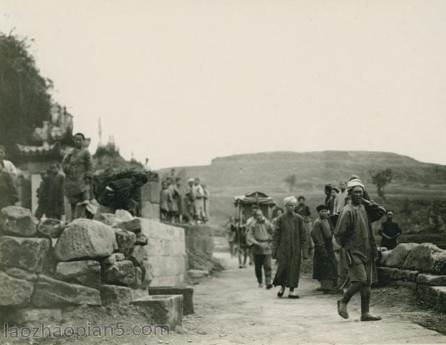
郑家屯公署,风车
郑家屯,即现在的双辽市城区,是一座历史悠久的古城。位于吉林省西部、双辽市境域西南部,地处吉林、辽宁、内蒙古三省(区)交界点,东、西辽河汇流处,坐落在西辽河的西岸上。郑家屯自古以来就以“辽河航道要冲”、“兵家必争之地”和“东北重镇”而闻名全国。
![图片[8]-Old photos of Xing’an Province during the Republic of China-China Archive](https://chinaarchive.net/photo/republic-of-china/1-201012223942-52.jpg)
郑家屯火车站,街道
![图片[9]-Old photos of Xing’an Province during the Republic of China-China Archive](https://chinaarchive.net/photo/republic-of-china/1-201012225155.jpg)
呼伦贝尔岩盐的开采
![[Qing Dynasty] British female painter—Elizabeth Keith, using woodblock prints to record China from the late Qing Dynasty to the early Republic of China—1915-China Archive](https://chinaarchive.net/wp-content/uploads/2022/11/image-191x300.png)