This is a group of old photos of Huludao, Liaoning in 1935;, The historical features of Huludao, Lianshan, Longxianchi, Dahushan and other places during the Republic of China were mainly photographed. This group of photos is from the Japanese magazineYadong Prints Collection.
The issue date of the magazine in which this group of photos is published was May 1935, so it is speculated that this group of photos may have been taken before May 1935.
The following photos:
Huludao, a prefecture level city in Liaoning Province, is located in the western coast of Liaoning Province. It is adjacent to Jinzhou in the east, Shanhaiguan in the west, Bohai Bay in the south, Chaoyang City in the north, Dalian, Yingkou, and the Emperor of Qin Dynasty Qingdao and other cities form the Bohai Rim Economic Circle, which is an important gateway for Northeast China to enter the Shanhaiguan Pass
![图片[1]-The old photos of Huludao in 1935 The style and features of the island and Lianshan area-China Archive](https://chinaarchive.net/photo/republic-of-china/1-220215222433.jpg)
1935年,葫芦岛风光。如今的葫芦岛市以此岛之名,于1994年将原来的锦西市改为葫芦岛市。
![图片[2]-The old photos of Huludao in 1935 The style and features of the island and Lianshan area-China Archive](https://chinaarchive.net/photo/republic-of-china/1-220215222434.jpg)
1935年,葫芦岛上海岸边停靠的船舶,几位船夫正在船上劳作。
![图片[3]-The old photos of Huludao in 1935 The style and features of the island and Lianshan area-China Archive](https://chinaarchive.net/photo/republic-of-china/1-220215222434-50.jpg)
1935年,葫芦岛海边风光。
![图片[4]-The old photos of Huludao in 1935 The style and features of the island and Lianshan area-China Archive](https://chinaarchive.net/photo/republic-of-china/1-220215222434-51.jpg)
1935年,葫芦岛一处货栈,货物正在运输盘驳,妇女和孩童或站立,或嬉戏。
![图片[5]-The old photos of Huludao in 1935 The style and features of the island and Lianshan area-China Archive](https://chinaarchive.net/photo/republic-of-china/1-220215222434-52.jpg)
1935年,连山地区风光。
连山区,隶属辽宁省葫芦岛市,位于葫芦岛市东北部,毗邻锦州、葫芦岛两大港口,北接京沈高速公路、高速铁路,102国道贯穿整个城区,是葫芦岛市的商贸、文化、金融中心。
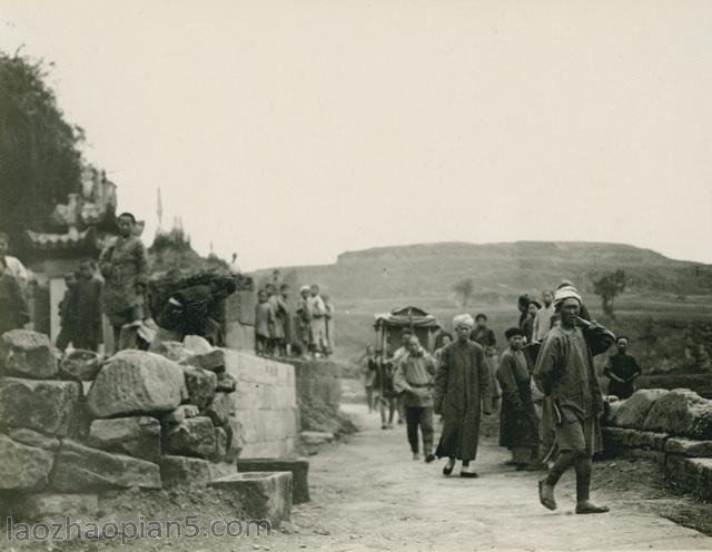
![图片[6]-The old photos of Huludao in 1935 The style and features of the island and Lianshan area-China Archive](https://chinaarchive.net/photo/republic-of-china/1-220215222434-53.jpg)
龙仙池
![[Qing Dynasty] British female painter—Elizabeth Keith, using woodblock prints to record China from the late Qing Dynasty to the early Republic of China—1915-China Archive](https://chinaarchive.net/wp-content/uploads/2022/11/image-191x300.png)