The old photo of Zhaotong, Yunnan in 1903 shows the urban and rural scenery and characters of Zhaotong 120 years ago. This group of photos is relatively early among the old photos of Zhaotong seen so far
Photograph of this group: Gallo. William Edgar Geil was a famous American traveler and a member of the Royal Geographical Society in the early 20th century. He was born in Doilston, Pennsylvania, USA in 1865. He has received strict and systematic professional training in geography and is deeply interested in Chinese history and culture. He came to China for the first time in 1903. He took a boat up the river from Shanghai to investigate the human geography of the Yangtze River basin and wrote the book Americans on the Yangtze River (1904), which was welcomed by western readers. Since then, he has come to China for several times to investigate. He has traveled all over the country, inside and outside the Great Wall, and three mountains and five mountains. He has published a series of works, including The Great Wall of China (1909), The Eighteen Provinces of China (1911), and The Five Mountains of China (1926)
Most of the old photos in this group are from Zhaotong, Yunnan, in Gallo’s American on the Yangtze River. Welcome to read them
Zhaotong is located in the northeast of Yunnan Province, in the hinterland of the Wumeng Mountains at the junction of Yunnan, Guizhou and Sichuan, and along the lower reaches of the Jinsha River. Zhaotong has historically been an important gateway for Yunnan Province to Sichuan and Guizhou, an important channel for Central Plains culture to enter Yunnan, and one of the three cradles of Yunnan culture. It is a famous“ South Silk Road” It is the key point of“ Key to Southern Yunnan, Throat to Xishu” It is an important channel for Yunnan to connect the Yangtze River Economic Belt and Chengdu Chongqing Economic Zone, and a two-way corridor from the mainland to South Asia, Southeast Asia and Yunnan to the mainland
ps: The description of the photo is based on Gallo’s English annotation at that time
![图片[1]-The old photos of Zhaotong, Yunnan in 1903. The urban and rural scenery and characters of Zhaotong 120 years ago-China Archive](https://chinaarchive.net/photo/qing-dynasty/1-200F6211618.jpg)
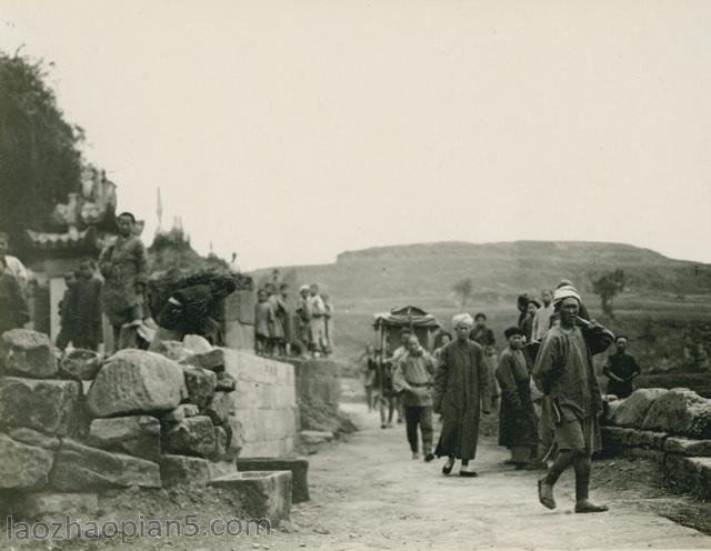
老鸦滩附近的寺庙,老鸦滩在现今的云南昭通盐津县
![图片[2]-The old photos of Zhaotong, Yunnan in 1903. The urban and rural scenery and characters of Zhaotong 120 years ago-China Archive](https://chinaarchive.net/photo/qing-dynasty/1-200F6211618-50.jpg)
老鸦滩(今昭通盐津县) 峡谷,两人身后是供行人歇脚的茶屋
![图片[3]-The old photos of Zhaotong, Yunnan in 1903. The urban and rural scenery and characters of Zhaotong 120 years ago-China Archive](https://chinaarchive.net/photo/qing-dynasty/1-200F6211617.jpg)
从昭通城墙上远眺,远处大屋的屋顶很是精美。
![图片[4]-The old photos of Zhaotong, Yunnan in 1903. The urban and rural scenery and characters of Zhaotong 120 years ago-China Archive](https://chinaarchive.net/photo/qing-dynasty/1-200F6211620.jpg)
彼时的昭通黑神庙,即张飞庙,牌匾上好像写的是忠烈宫。黑神庙现已不存,位置可能在现在的大局街。
搜索得知黑神庙是忠烈宫或忠烈庙的俗称,为祭祀南霁云的民间宗教庙宇,清同治版《来凤县志》载:“黑神庙,在元阜里后坪,祀唐睢阳殉难南将军霁云。”史载唐安禄山反,张巡起兵抗击,后与许远同守战略要地睢阳(今河南省商丘市),南霁云、雷万春为张巡得力部将。后粮尽援绝,睢阳陷落,张巡、许远等被虏,尹子奇斩张巡、南霁云、雷万春等36人。韩愈在《张中丞传后叙》中记载了南霁云生前的忠勇和死的壮烈。
![图片[5]-The old photos of Zhaotong, Yunnan in 1903. The urban and rural scenery and characters of Zhaotong 120 years ago-China Archive](https://chinaarchive.net/photo/qing-dynasty/1-200F6211620-50.jpg)
昭通黑神庙内的戏台
![图片[6]-The old photos of Zhaotong, Yunnan in 1903. The urban and rural scenery and characters of Zhaotong 120 years ago-China Archive](https://chinaarchive.net/photo/qing-dynasty/1-200F6211621.jpg)
昭通望海楼
英文标注意思应该是昭通文庙旁的塔,图片看上去像望海楼或者是旧时的八角亭。
![图片[7]-The old photos of Zhaotong, Yunnan in 1903. The urban and rural scenery and characters of Zhaotong 120 years ago-China Archive](https://chinaarchive.net/photo/qing-dynasty/1-200F6214352E0.jpg)
如今的望海楼
望海楼又名恩波楼位于昭通城南郊凤凰山脚下, 清乾隆二十五年(公元1760年)恩安县知县沈生遴建。咸丰年间,望海楼毁于战火。光绪年间,邑绅杨履乾倡议并筹资重建。楼门题写楹联:“万千气象满垌野,杨柳楼台接凤凰。”2010年再次修缮完工后,“昭阳八景”之一的“恩波蜃影”再次以全新的面貌展现在市民的面前。
![图片[8]-The old photos of Zhaotong, Yunnan in 1903. The urban and rural scenery and characters of Zhaotong 120 years ago-China Archive](https://chinaarchive.net/photo/qing-dynasty/1-200F6211619-50.jpg)
昭通,大水井石牌坊。这个大水井不知道是否代表的是昭通市鲁甸县大水井乡?
![图片[9]-The old photos of Zhaotong, Yunnan in 1903. The urban and rural scenery and characters of Zhaotong 120 years ago-China Archive](https://chinaarchive.net/photo/qing-dynasty/1-200F6211619.jpg)
作者盖洛在镜头前展示自己所乘坐的滑竿!
![图片[10]-The old photos of Zhaotong, Yunnan in 1903. The urban and rural scenery and characters of Zhaotong 120 years ago-China Archive](https://chinaarchive.net/photo/qing-dynasty/1-200F6211621-50.jpg)
当地的一个老妇人正在抽旱烟。
![图片[11]-The old photos of Zhaotong, Yunnan in 1903. The urban and rural scenery and characters of Zhaotong 120 years ago-China Archive](https://chinaarchive.net/photo/qing-dynasty/1-200F6211622.jpg)
当地的一位贵妇人。
![图片[12]-The old photos of Zhaotong, Yunnan in 1903. The urban and rural scenery and characters of Zhaotong 120 years ago-China Archive](https://chinaarchive.net/photo/qing-dynasty/1-200F6211616.jpg)
原英文标注为:Caves at Shin Gai North And Old Hero Barbarians, Westen China.
![图片[13]-The old photos of Zhaotong, Yunnan in 1903. The urban and rural scenery and characters of Zhaotong 120 years ago-China Archive](https://chinaarchive.net/photo/qing-dynasty/1-200F6211617-50.jpg)
从昭通去往云南府的路上,一个简陋的路边茶室。
清末时期的昭通古城还是有很多特色建筑的,可惜现在很多已经看不到了。尤其是哪个牌坊很有特色,不知道现在还在不在?
![[Qing Dynasty] British female painter—Elizabeth Keith, using woodblock prints to record China from the late Qing Dynasty to the early Republic of China—1915-China Archive](https://chinaarchive.net/wp-content/uploads/2022/11/image-191x300.png)